
Cape Canaveral Air Force Station Maps
This page serves as a repository for Cape Canaveral Air Force Station maps.
This map, dated 21 June 1962, shows NASA Launch Operations Center (today known as the Kennedy Space Center) space utilization at Cape Canaveral Air Force Station.
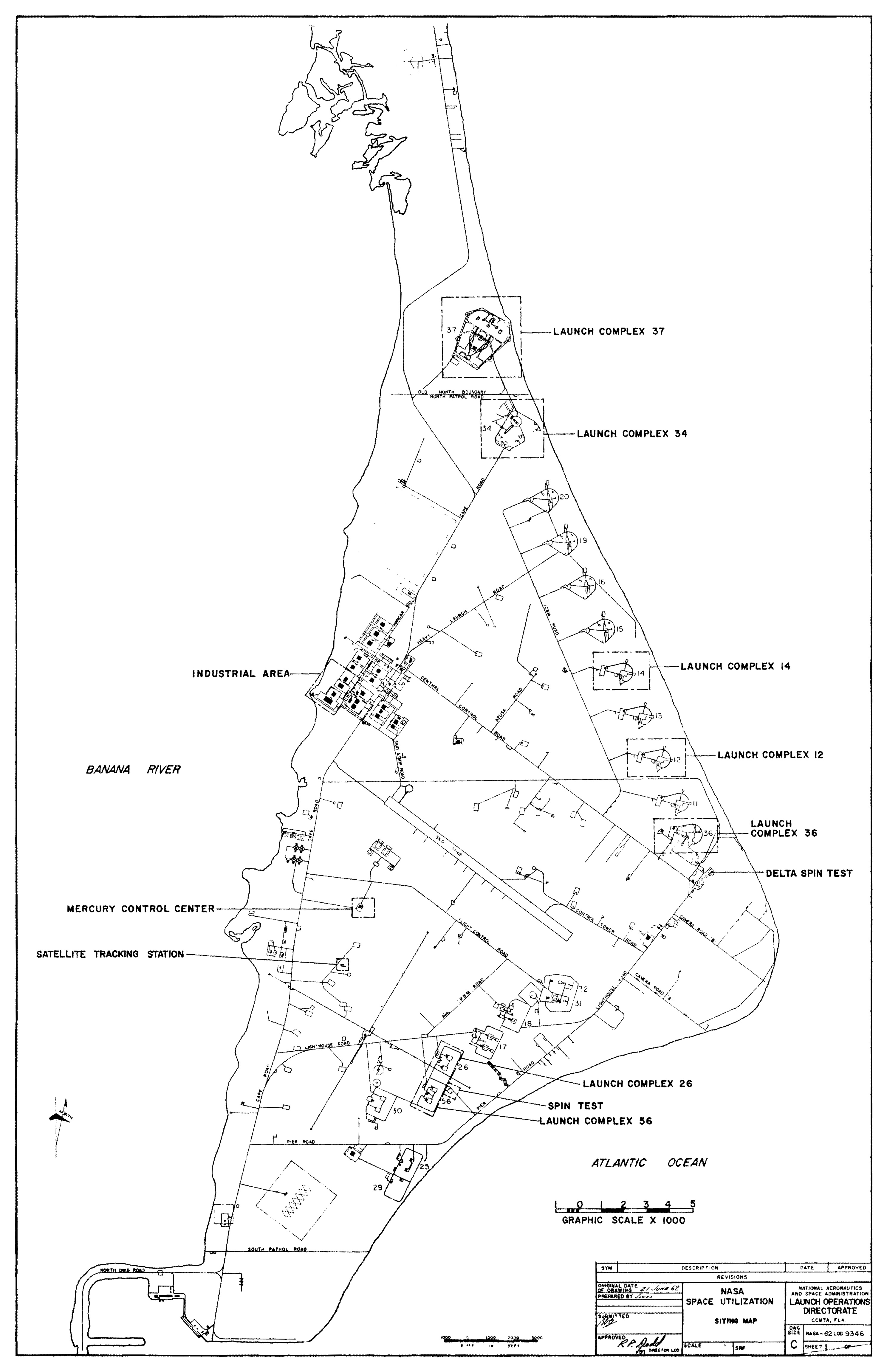
Click image for a 2975x4605 pixel version of this image in a new window.
From NASA Launch
Operations Center Space Utilization at AMR.
Extraction and clean up by heroicrelics.
Highlights on the map include the Mercury Mission Control Center; the Industrial Area; LC-37 and LC-34, used for Saturn I (and, later, Saturn IB launches); Launch Complex 14, an Atlas missile pad, from Mercury-Atlas and later Gemini Agena Target Vehicle missions were launched; Launch Complex 12, another Atlas pad, from which various satellites and lunar probes were launched; Launch Complex 36, which launched Atlas-Centaur vehicles; Launch Complex 26, from which Explorer I, America's first satellite, was launched; and LC-5/6, from which the Mercury-Redstone missions were launched.
Launch Complex 19, from which the Air Force test-launched Titan I and Titan II missiles, is shown on the map but not called out, as Project Gemini was not yet underway. From 1964 to 1966 (about two years after this map was published), NASA launched Gemini-Titan missions from LC-19.
This map, taken from a booklet from the first half of 1964 (when CCAFS was called Cape Kennedy Air Force Station), shows the route of a driving tour when it was open to the public.
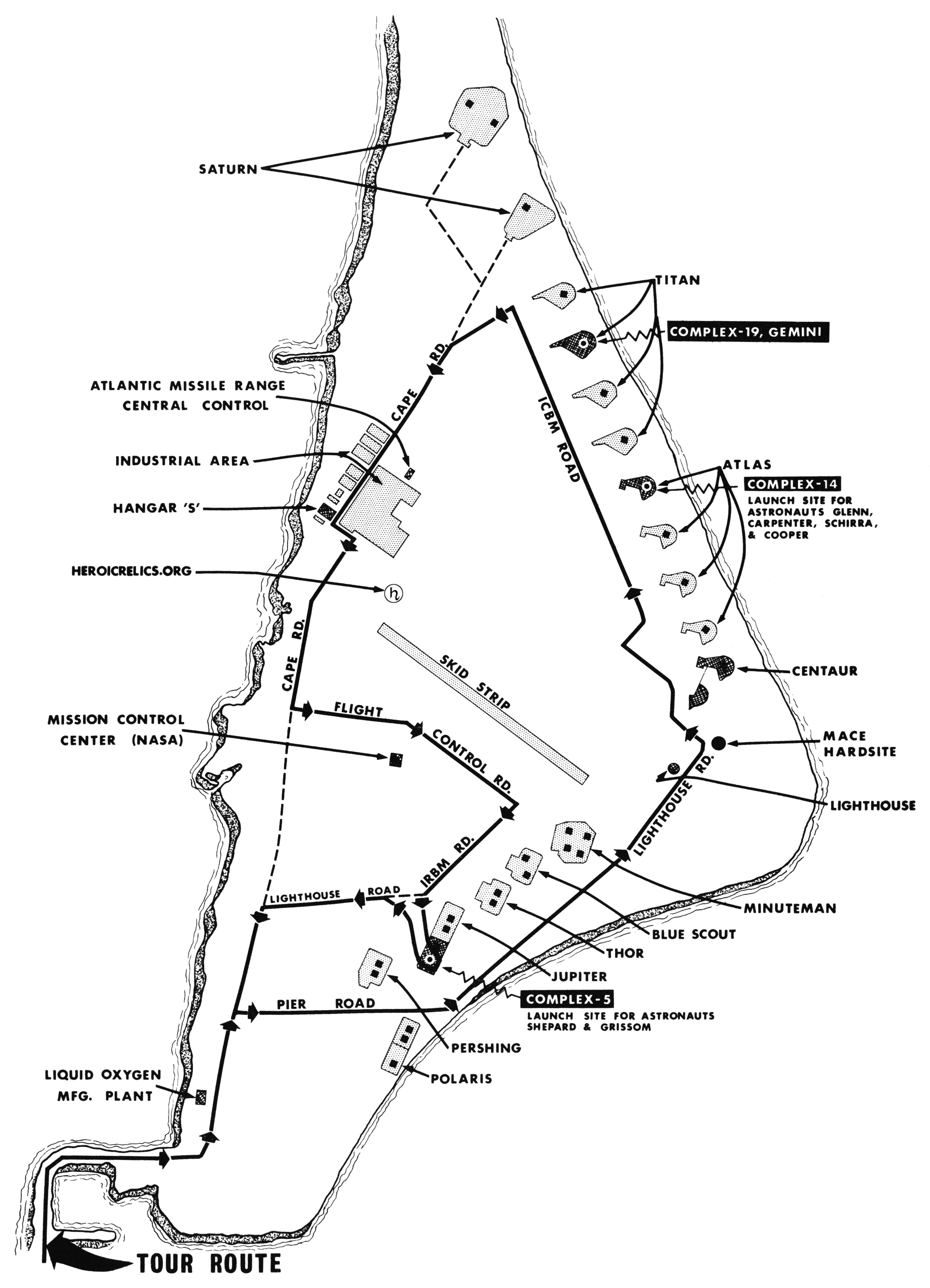
Click image for a 2891x4006 pixel version of this image in a new window.
From my Welcome to Cape Kennedy Air Force
Station booklet.
Scan and reconstruction by heroicrelics.
Highlights on the map include the Mercury Mission Control Center; Hangar S; LC-37 and LC-34, labelled simply "Saturn"; Titan pads, including LC-19, from which the Gemini missions were launched; Atlas pads, including LC-14, from which the Mercury-Atlas missions were launched; the Cape Canaveral lighthouse, pads for Blue Scout, Thor, and Jupiter; and LC-5/6, from which the Mercury-Redstone missions were launched.
This map lists not only the launch complexes, but also the missiles launched from them. This undated map would seem to have been prepared after the Trident wharf and turning basin (the east-most, northern California-shaped basin in Port Canaveral) was dredged, which was done in the 1974-75 timeframe. I find it somewhat odd that the map shows several launch complexes as "deactivated" (e.g., Complex 19 was deactivated after the last Gemini mission), but LC-34 and LC-37 are not so marked (NASA headquarters announced in May 1970 that all Skylab launches were to take place at LC-39, thereby rendering LC-34 and LC-37 unnecessary).
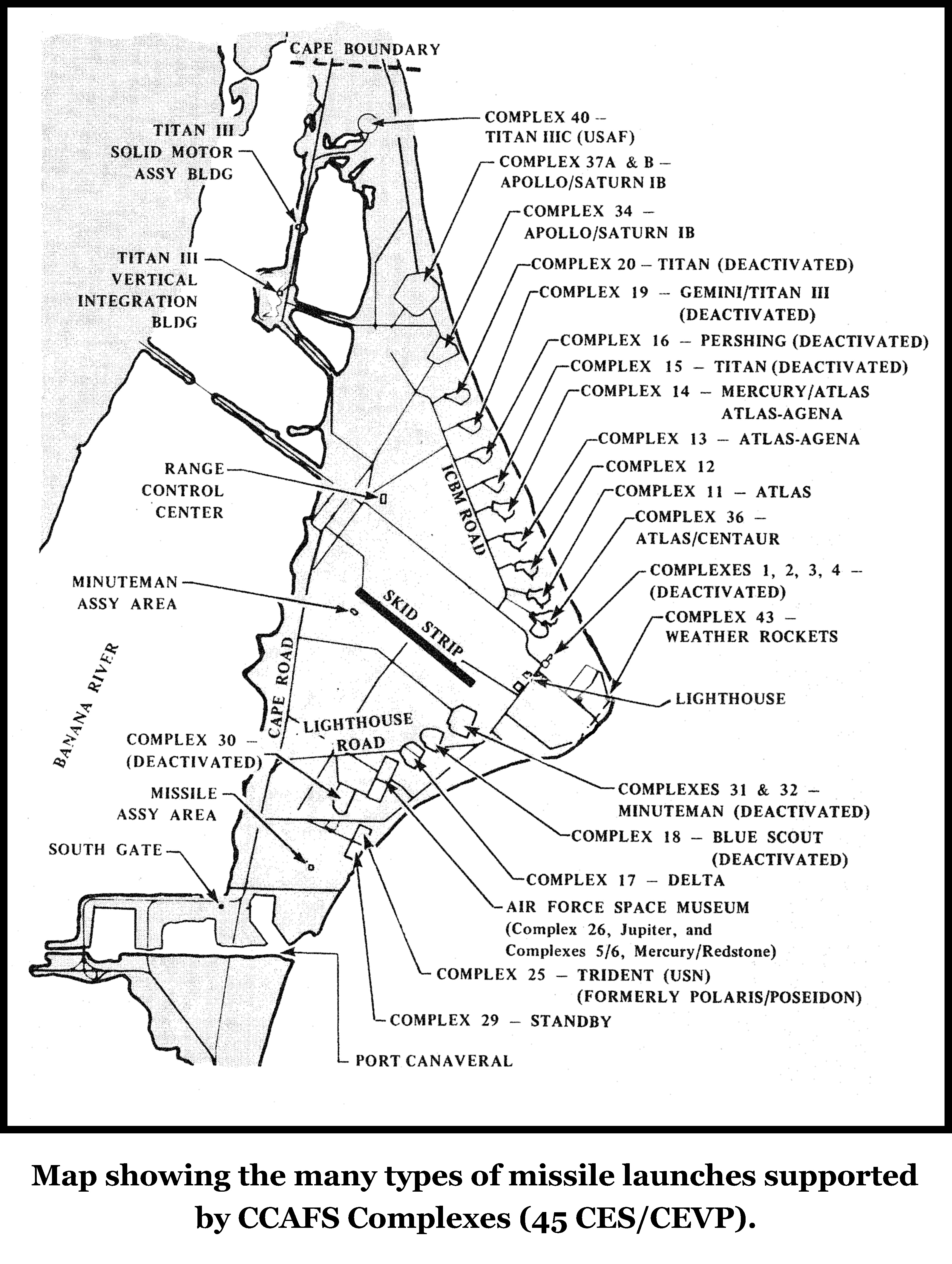
Click image for a 3187x4228 pixel version of this image in a new window.
From page 103 of the Level II
Documentation of Launch Complex 31/32, Cape Canaveral Air Force Station,
Florida.
Extraction and cleanup by heroicrelics.
This map includes
- Complex 40 - Titan IIIC (USAF)
- Complex 37A & B - Apollo/Saturn IB
- Complex 34 - Apollo/Saturn IB
- Complex 20 - Titan (Deactivated)
- Complex 19 - Gemini/Titan II (Deactivated)
- Complex 16 - Pershing (Deactivated)
- Complex 15 - Titan (Deactivated)
- Complex 14 - Mercury/Atlas, Atlas/Agena
- Complex 13 - Atlas/Agena
- Complex 12
- Complex 11 - Atlas
- Complex 36 - Atlas/Centaur
- Complexes 1, 2, 3, 4 - (Deactivated)
- Complex 43 - Weather Rockets
- Complex 31 & 32 - Minuteman (Deactivated)
- Complex 18 - Blue Scout (Deactivated)
- Complex 17 - Delta
- Air Force Space Museum (Complex 26, Jupiter, and Complexes 5/6, Mercury/Redstone
- Complex 30 - (Deactivated)
- Complex 25 - Trident (USN) (Formerly Polaris/Poseidon)
- Complex 29 - Standby
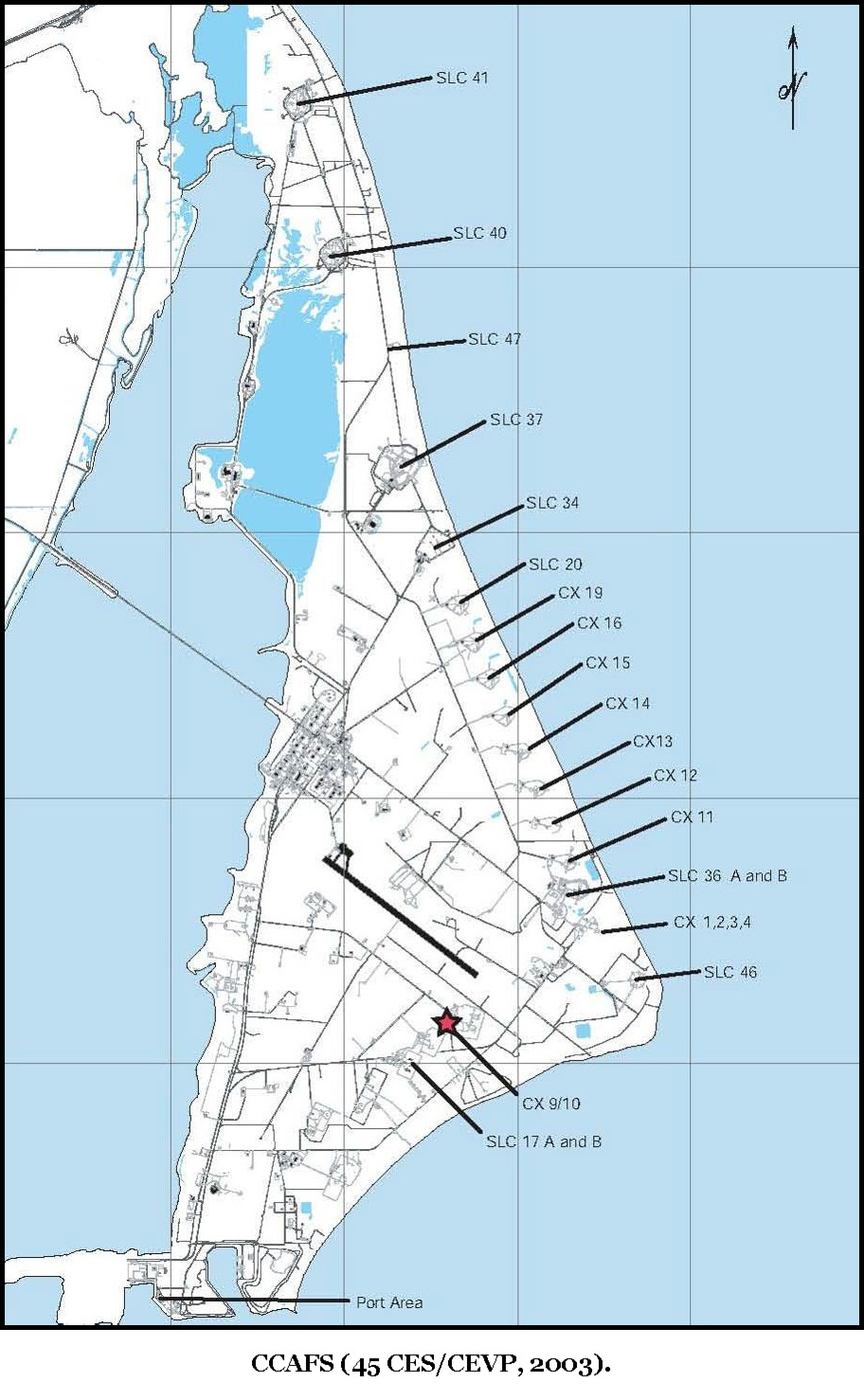
Here are two newer maps, dating to 2003 and 2006:
Click image for a 912x1478 pixel version of this image in a new window.
From page 104 of the Level II
Documentation of Launch Complex 31/32, Cape Canaveral Air Force Station,
Florida.
Although this map is copyrighted, the source document notes that
"distribution is unlimited."
Extraction and cleanup by heroicrelics.
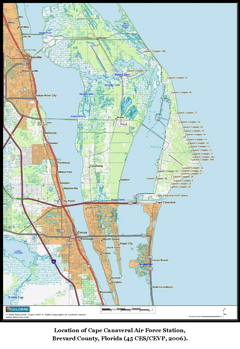
Click image for a 801x1164 pixel version of this image in a new window.
From page 100 of the Level II
Documentation of Launch Complex 31/32, Cape Canaveral Air Force Station,
Florida.
Extraction and cleanup by heroicrelics.