
Naval Aviation Museum's Flight Line
I frequently use Google Maps to document the location of large, outdoor objects. Google is always updating its aerial imagery, which is usually useful, but if those objects move over time, Google Maps suddenly becomes less useful.
heroicrelics.org is dedicated to documenting historical information, so I've used the "Historical Imagery" feature of Google Earth to go back in history to document the Naval Aviation Museum's flight line. (BTW, Google's current imagery is available here.)
For the most part, this page will concern itself with artifacts documented on my Naval Aviation Museum page.
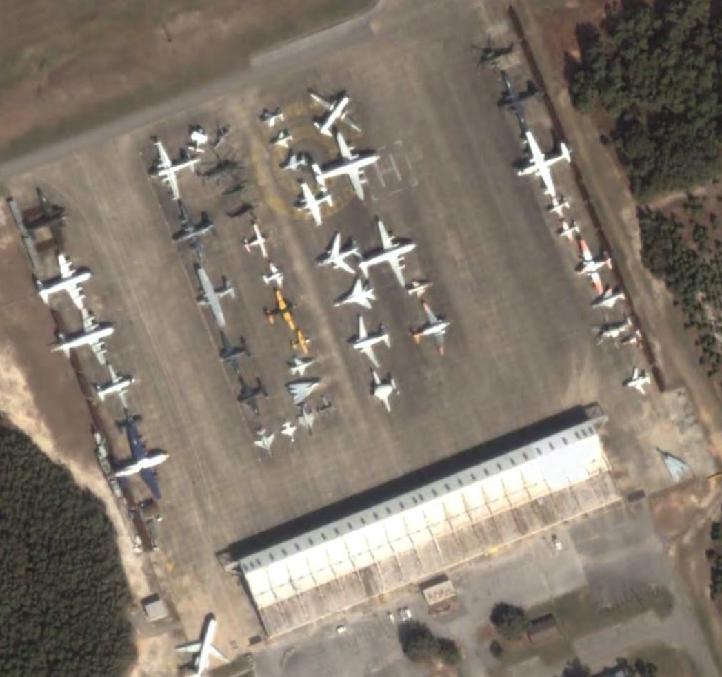
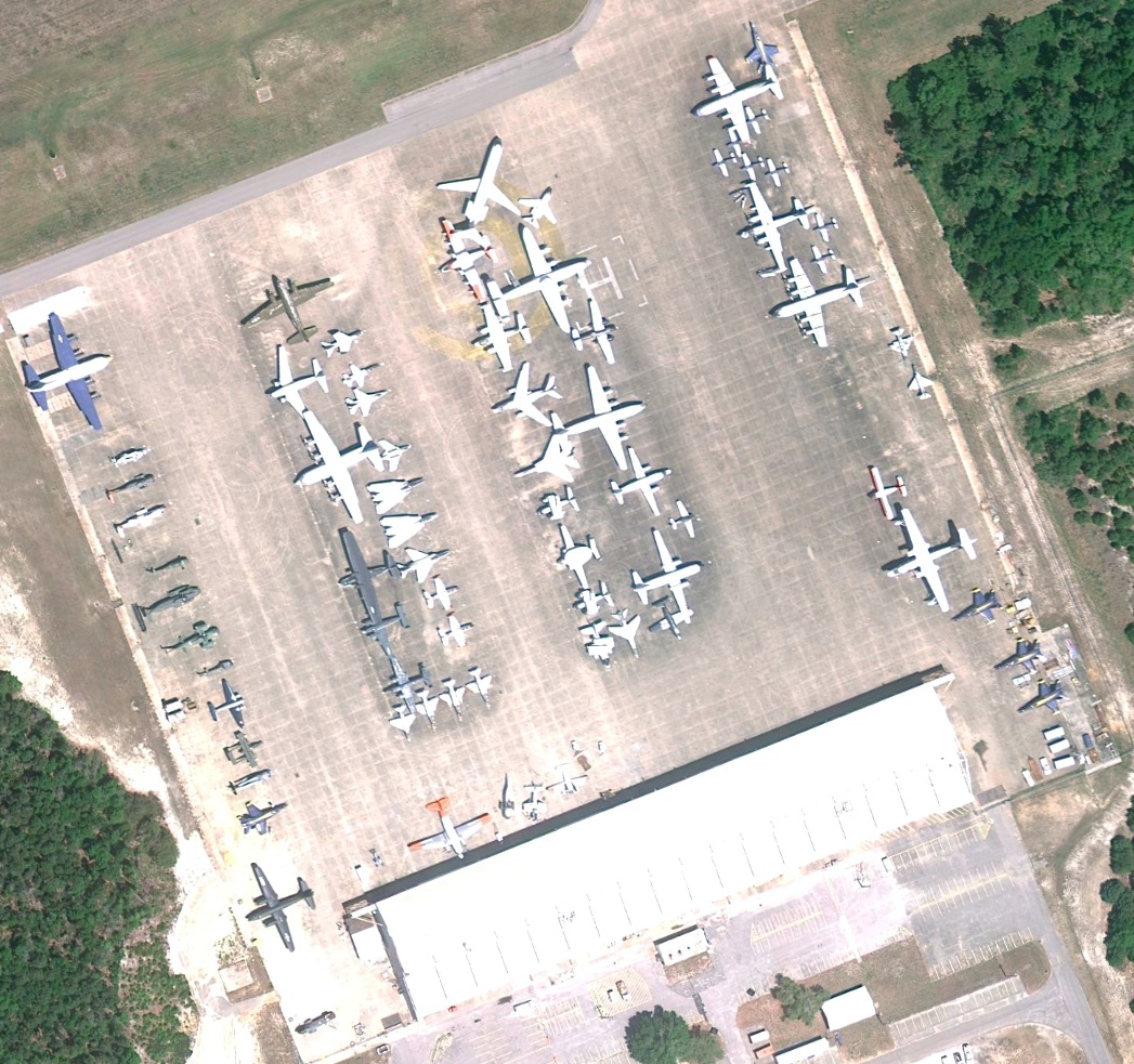
March 14, 2003
The flight line consists of two outer rows, at the edges of the apron, with two double "rings" of aircraft in the center of the apron.
Aircraft locations:
- R4D (silver plane with orange empennage and wingtips): Near the bottom right of the right-most center ring.
- S-58: Appears to be the lower of the three olive drab aircraft near upper right of the left-most center ring.
Click image for a 1047x983 pixel version of this image in a new window.
Imagery courtesy Google Earth.
Capture by heroicrelics.
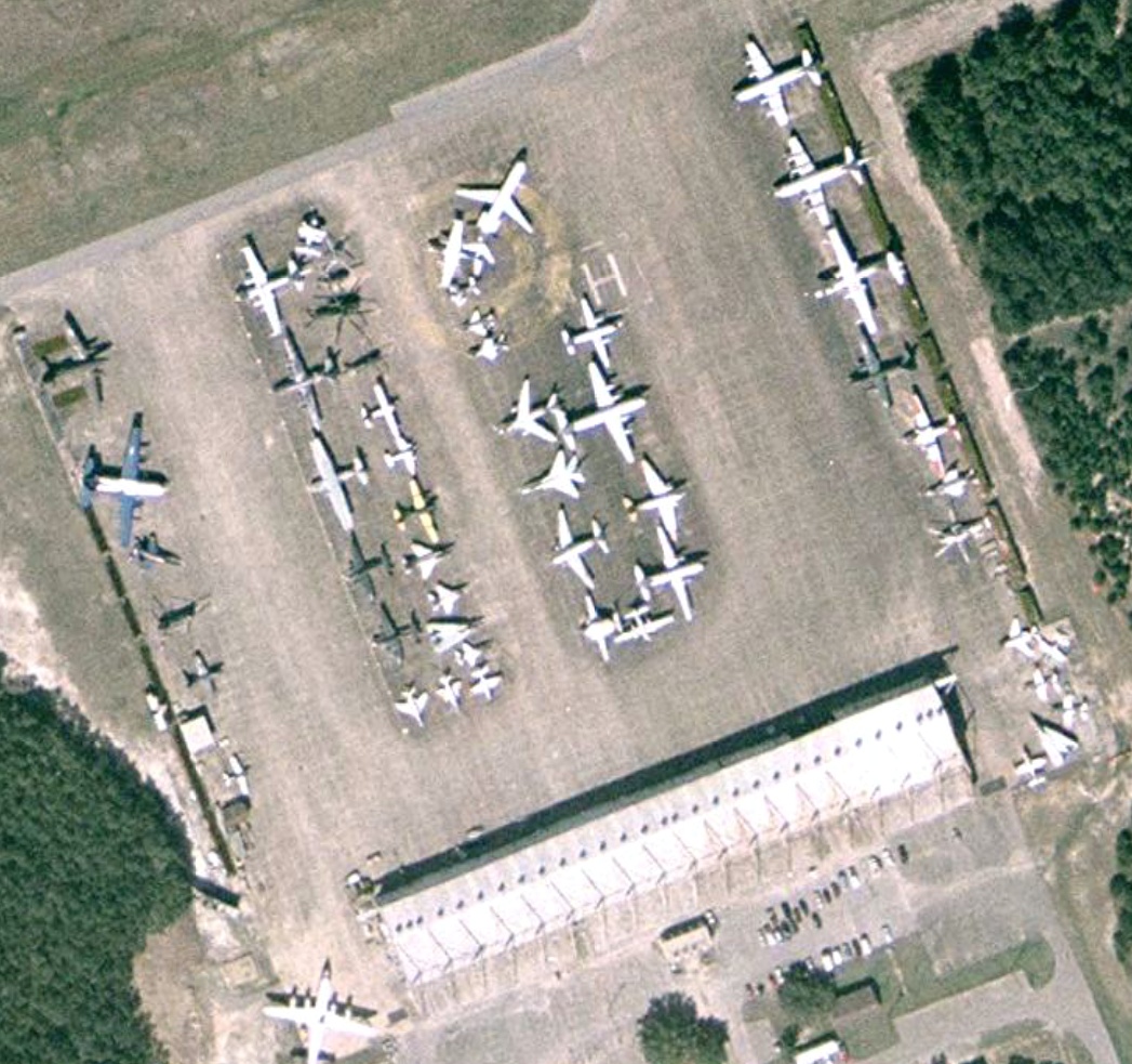
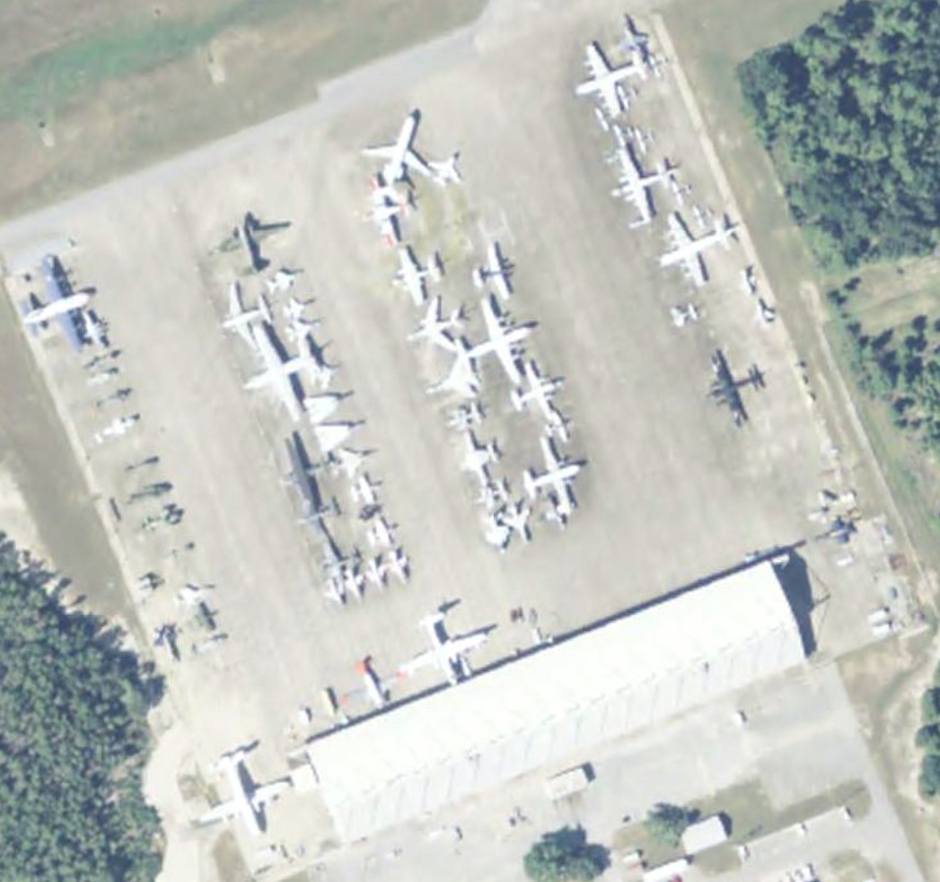
March 30, 2004
The flight line consists of two outer rows, at the edges of the apron, with two double "rings" of aircraft in the center of the apron.
Aircraft locations:
- R4D (silver plane with orange empennage and wingtips): Still near the bottom right of the right-most center ring, but another plane has been added off its starboard wing.
- S-58: Appears to be the lower of the two olive drab aircraft near upper right of the left-most center ring (the middle helicopter was removed).
Click image for a 1047x983 pixel version of this image in a new window.
Imagery courtesy Google Earth.
Capture by heroicrelics.
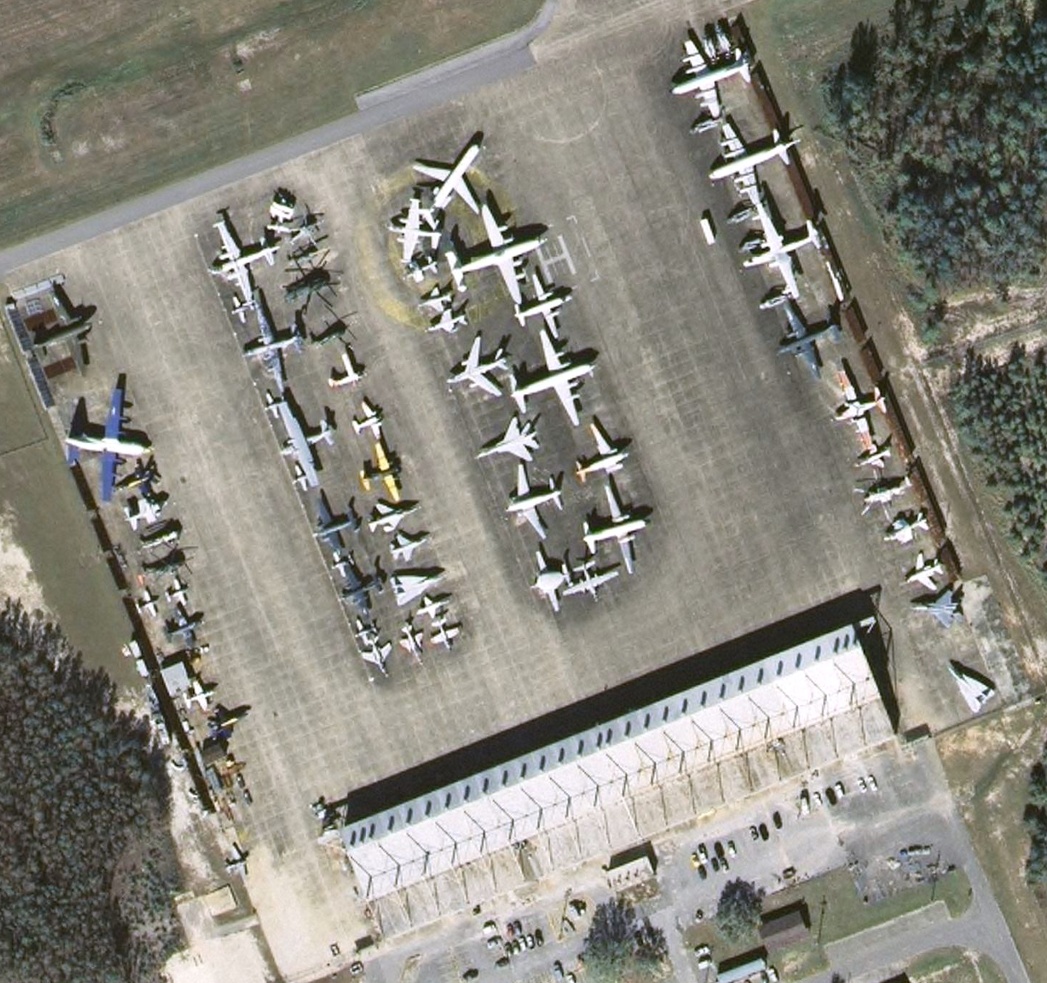
December 30, 2004
The flight line consists of two outer rows, at the edges of the apron, with two double "rings" of aircraft in the center of the apron.
Aircraft locations:
- R4D (silver plane with orange empennage and wingtips): Still near the bottom right of the right-most center ring. The restoration crew has removed its starboard wing; this is the condition of the plane when I visited the museum in June of 2005.
- S-58: Appears to be the lower of the two olive drab aircraft near upper right of the left-most center ring.
Click image for a 1047x983 pixel version of this image in a new window.
Imagery courtesy Google Earth.
Capture by heroicrelics.
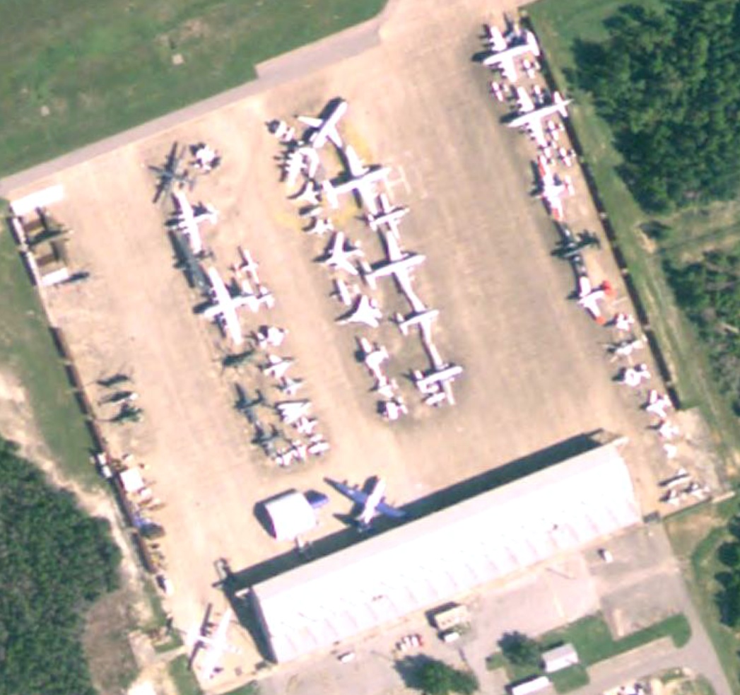
November 12, 2007
The flight line consists of two outer rows, at the edges of the apron, with two double "rings" of aircraft in the center of the apron.
Aircraft locations:
- R4D (silver plane with orange empennage and wingtips): The aircraft has been reunited with its starboard wing and has been moved to the middle of the right-hand outer row. There's a plane with orange wingtips, a darker plane, and then another plane with orange wingtips; I believe the R4D is the lower of the these planes.
- S-58: Appears to be the center of the three olive drab aircraft near the center of the left-hand outer row. The rotor blades may have been removed.
Click image for a 1047x983 pixel version of this image in a new window.
Imagery courtesy Google Earth.
Capture by heroicrelics.
April 24, 2010
The flight line consists of two outer rows, at the edges of the apron, with two double "rings" of aircraft in the center of the apron.
Aircraft locations:
- R4D (silver plane with orange empennage and wingtips): The aircraft has been moved closer to the building at the bottom of the photo.
- S-58: Smallest of the three olive drab aircraft near the center of the left-hand outer row (immediately below a larger, all-white aircraft). The rotor blades have definitely been removed by this time.
Click image for a 1047x983 pixel version of this image in a new window.
Imagery courtesy Google Earth.
Capture by heroicrelics.
May 8, 2010
The flight line consists of two outer rows, at the edges of the apron, with two double "rings" of aircraft in the center of the apron.
Aircraft locations:
- R4D (silver plane with orange—or perhaps red—empennage and wingtips): The aircraft is still near the building at the bottom of the photo.
- S-58: Smallest of the three olive drab aircraft near the center of the left-hand outer row (immediately below a larger, all-white aircraft). The aircraft is without its rotor blades.

Click image for a 1047x983 pixel version of this image in a new window.
Imagery courtesy Google Earth.
Capture by heroicrelics.
December 30, 2010
The flight line consists of two outer rows, at the edges of the apron, with two double "rings" of aircraft in the center of the apron.
Aircraft locations:
- R4D (silver plane with orange—or perhaps red—empennage and wingtips): The aircraft is still near the building at the bottom of the photo.
- S-58: Smallest of the three olive drab aircraft near the center of the left-hand outer row (immediately below a larger, all-white aircraft). The aircraft is without its rotor blades.
Click image for a 1047x983 pixel version of this image in a new window.
Imagery courtesy Google Earth.
Capture by heroicrelics.
By June 3, 2011, the R4D no longer appears in the aerial imagery, so the R4D must have been moved indoors some time between December 30, 2010 and June 3, 2011.
As of early 2018, the S-58 is still in approximately the same location on the flight line.